Monday, 26 December 2016

My kind of poolside resort

If our safari in the Ngorongoro Conservation Area in Tanzania had included one full day at the Hippo Pool, I would have been only too happy. As it was, our 45 minute halt at the Hippo Pool was a mad frenzy filled with "Woah, look at that hippo!"s, "Ooh look behind you"s, "Did you get a picture of that bird yet"s and many similar attempts to identify and photograph every bird/animal in that little ecosystem. The following photo describes our first view of the Hippo Pool, as we approached it in our open-topped Safari jeep.
First look at the Hippo Pool

If the name Hippo Pool still doesn't make sense, look a little harder at those rocks. Yup, those are HIPPOS! We'll get back to them in a moment.
Can you spot the Little Egret among these Sacred Ibises?


But first, a look at this group of Sacred Ibises perched on a bush, rooting around for food. Double take. There's an impostor in their ranks - a clear white Little Egret, plumb in the middle of the bush. What gave it away was the distinct lack of dark plumes that are found on the rear end of the Ibises.


African Buffalo

A sudden rustle directs our attention to the left. An African buffalo slowly making its way through the bushes, trying to remain inconspicuous and failing because of its tremendous size. Despite its threatening and often violent demeanor, the African buffalo is a herbivore, feeding on grasses and shrubs. Perhaps wading through cool water on hot day made for very pleasant feeding?


Black-headed heron


And who do we have here? A Black-Headed heron popping out of the brambles, keeping a sharp eye out for his next meal - perhaps a little insect or rodent.


Great  White Pelicans


Turning our eyes back to the water, we are enraptured by these large, brilliant birds. A pair of Great White Pelicans, out fishing.


Green-backed heron, the dull brown ones
are probably juveniles


Now lets turn our attention back to - oh no wait! That patch of grass just above the pool is littered with at least a dozen birds. The bright green birds rather look like Green-backed herons while the white spotted brown birds are probably juveniles of the same species.


And now a look at the gargantuan species after whom the Hippo Pool is named. On a hot day like this one, the hippos are enjoying a lazy time cooling off in the water. A red billed oxpecker is perched on the back of one of the hippos, ridding it of ticks and other insects.
Hippopotamuses, with their heads barely above the water
A red bill oxpecker is busy eating ticks off the Hippo's back

Hippos are solitary grazers and collect only in ponds and mud of this sort. One hippo seems to have spent far too long on lunch and is hurrying to join his buddies for the pool party.

Trotting towards the pool

Clambering in

Wading through the pool to join his friends.
Spotted hyena in the backdrop

He splashes in, while a spotted hyena cautiously approaches the pool behind him. While hyenas are usually found in their hunting packs, this canine seems to have ventured a little way from its pack in search of a drink of water. We follow the hyena with our eyes as he walks back to his pack, all of whom are stretched out on a farther bank of the pool. Only now do we notice the large group of Cattle Egret lined up on the bank of the pool behind us.
Line of Cattle Egret
Cinnamon chested bee eater
Blacksmith Lapwings alongside Wood Sandpipers
As we watch the hippos splash excitedly in the water, the pelicans sail from end to end in unison and the hyenas drift into their midday naps, we notice numerous other little birds having a field day at the Hippo Pool.

African Black Crake


Can someone tell us who this is???
We depart the incredibly alive Hippo Pool, gazing back longingly and imagining the dozens of other birds and little critters that had gone unnoticed by us.


Friday, 23 December 2016

Kilimanjaro: A cornucopia of landscapes

Our Kilimanjaro climb was unlike any other hike we've done before. For one thing, instead of hiking for 1 or 2 days, we hiked for 7 days. For another, the ascent from 5000ft to 19000ft meant that we encountered a new climate and vegetation zone almost every day. Each morning afforded a new magnificent view, varied weather conditions and a changing landscape to look forward to.
Blue monkeys
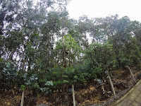
Hiking through the rain forest on day 1
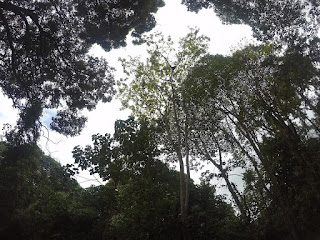
A leisurely stroll through the rain forest made up most of our first day. Blue monkeys called to us from the trees as we set off; we kept an eye out for their Colobus cousins but we didn't spot any that day. As we made our way through the thicket of trees and bushes, we felt like we could have been hiking back home in Washington state, USA. The mild drizzle, our constant companion during the hike that day, evolved into a thick fog by the time we reached Machame camp. The vegetation appeared to be changing slightly but we couldn't see the extent of it yet.


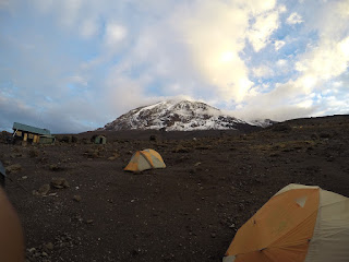
View from Machame camp
The next morning we awoke to find that the fog of the previous night had completely cleared and we had a beautiful view of the peak waiting for us. Eagerly scrambling out of our tent each morning in anticipation of the new view we'd see became something of a daily routine for us. This morning was our first glimpse of the Kibo volcano, our destination. It was also interesting to see that the trees were getting much shorter than they had been on the previous day.
Hiking through heathers and lichen laden rocks
Best guess : Everlasting Helichrysum?
Lobelia plant


Day 2 was a steep climb amidst heathers and lichen laden rocks. Compared with the gravel of the previous day, the rocky path, made slippery by the rain, proved to be quite challenging to walk on. The vegetation was certainly thinning out and we spotted a couple of interesting looking plants. As with the previous day, the clouds started rolling in about noon, meaning that we couldn't see much more than our tents once we got to Shira camp. 
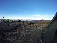
Mt Meru at a distance
Kibo, as seen from Shira camp
The morning of day 3 brought spectacular views on both sides of our tent. On the one hand, there was Mt Meru in the distance. At Shira camp, which was 12000ft, Meru still had about 3000ft on us. But we'd be neck and neck in terms of elevation by the end of the day. On the other side was a view of Kibo against the sunshine, far closer than it had been the previous morning. White necked raven trotted around the campsite, hoping to pick up scraps from one of the scores of tents at Shira that morning.


Hiking to Lava Tower
Approaching Lava Tower
Senecio Kilimanjaro
That morning we hiked towards the Lava Tower camp, planning to stop there for lunch and acclimatization. The thinning of vegetation continued that day, with the heather trees giving way to smaller shrubs. In fact, by the time we reached Lava Tower the landscape was almost devoid of greenery and dominated by large rocks. Lava Tower camp is so named after a large rock formed from cooled lava of a previous eruption.

After recharging with a hot beverage and lunch at Lava tower, we stuck around for a while trying to acclimatize and also photograph the 4-striped mice (quite in vain, these wily little creatures darted away before we could get the GoPro focused on them). A sudden hailstorm had us scurrying away from Lava Tower, trying to get away as fast as we could without slipping on the rocks. Focused on our steps and on staying dry in the rain, it was a while before we noticed that the landscape was changing once more - and this time there were some strange plants dominating the views. Senecio Kilimanjaro - from a distance, they looked like a giant cactuses but a closer inspection revealed tall, thick-stemmed plants with succulent leaves. Our climbing guide said these were native to the slopes of Kilimanjaro. They stayed with us all the way to Barranco camp, participating in the morning view on day 4.
Senecio, Kibo and the Barranco Wall, as seen from Barranco camp

The Barranco wall - our formidable undertaking for day 4


Barranco wall, as the name suggests was just that, a WALL! Rocks upon rocks meant a pretty steep scramble for us although once on the trail, we realised that it wasn't actually treacherous, just tiring. Luckily, we had to endure the scramble for just about 2km. When we reached the top of the wall, our first thought was to get a photograph of the steep cliff we had just climbed. But alas, the midday fog had rolled in early that day, eclipsing the view completely.
  
All fours on the Barranco wall


Atop the Barranco wall, the would-be view
completely masked by the fog


The showers we encountered on our way down to the Kaaranga camp would prove to be the worst rain of the trip. As soon as we hit camp, we retired to the warmth and dryness of our tent and only ventured out later that evening, when the sun had set and the clouds had somewhat cleared. For the first time since we had begun our ascent, we could see the lights of a city far in the distance. Was that Arusha?
Lights from the city below
First view of the open face of the mountain
A four-striped mouse


The clarity of the morning in Kaaranga gave us our first view of the snow-covered mountainside we were to summit in under 24 hours. We also finally managed to sneak in a picture of a four-striped mouse before it darted away from us. Our goal for the day was to hike to the Kilimanjaro base camp, Barafu, by midday. As we hiked through the barren, rocky trail that morning, we started noticing a number of rock piles on both sides. We were used to seeing these occasionally as trail markers but this one area had scores and scores of them. Our guide explained that people often built these as symbols of good luck for travelers passing by after them. Tempting as it was to stop and add our own legacy to the mountainside we pushed ahead, eager to reach the base camp as soon as possible.
Good luck rock piles
Fresh snowfall greeted us as we approached Barafu camp. It was as if the mountain was warning us of what was to come. After a quick lunch, we retired to our tents for an afternoon nap - we needed to rest up in preparation for our summit bid that night.
At about 11.30pm that night, we began the final ascent. Enveloped in pitch darkness, we had only our headlamps to help us navigate the 4000ft, 5km climb to Uhuru peak, the highest point of the Kibo volcano. And oh yes, the path was completely snow covered. After 7 hours and almost 4km of grueling climbing, we reached Stella Point just in time for daybreak and our morning ritual - a beautiful new view. Except this morning view surpassed any others we had ever seen!
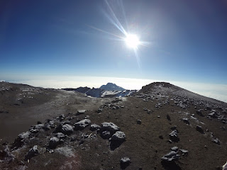
Sunrise at Stella Point, the extinct Mawenzi volcano in the distance
At Stella point, with Uhuru peak in the backdrop
on the right
The sunrise on the horizon made the snow all around us glisten and scattered its rays over the Mawenzi peak (another one of Kili's volcanoes) in the distance. We soaked in the warmth of the sunshine and caught whiffs of sulphur from the volcano crater. And there was Uhuru Peak, just a stone's throw away (or so we thought, at least). Bolstered by being so close to our goal, we set off on what would be nearly an hour long trek to the true peak of the mountain. The Redmond glacier glittered on our left as we huffed and puffed our way to Uhuru.
Redmond Glacier


With the oxygen levels nearly half of what they had been on our first day at the trailhead, we were now pausing for deep breaths after every step. When we finally stepped on Uhuru peak and managed to catch our breath, we were mesmerised by the phenomenal views on all sides - the volcano crater on one side, glaciers on both sides, the sun blazing down on us with Mawenzi right below it and even Mt Meru, far, far below us in the distance.


Volcano crater in the middle, another glacier on the left
Mawenzi peak, overshadowed by the sun
Triumphant on the Uhuru Peak, with Mt Meru far behind us
Six days of hard work, varied climates and diverse environments would breeze past us as we descended in just under 24 hours. By that night we were down to 10000ft, similar to the altitude of our first night on the mountain. We caught our final glimpse of Kibo the next morning, as it peeked out from behind the trees of the rainforest.
Kibo, as seen from Mweka camp
We thought that that would be our last exciting encounter with the Kili flora and fauna but we were wrong! We finally caught sight of the elusive Colobus monkeys, not 500ft from Mweka gate and the end of our journey. A group of them were hanging high up above us in the tall trees that fed them. It was as if they had assembled to bid us goodbye!
Colobus monkeys, high up in the trees

Sunday, 20 July 2014

Caterpillar Campers

"Spring is my favourite time of the year. My brothers and sisters and I camp out in the woods, surrounded by raspberry shrubs and other fruity plants. We pitch our tent in a vast, open area so that we can bask in the morning sun. Most of the day is spent hunting for delicious food and once we've eaten our fill, we return to our tent to lazily while away the rest of the day. 
Ah, I am truly alive this time of year!"
- A tent caterpillar who would like to remain anonymous

  
The sunny ledge on the mountain
The Poo Poo Point Chirico trail in Issaquah, WA is a short little 3.6 mile trail that nonetheless leaves you quite out of breath by the time you reach the summit. Just before the final steep push to the very top is a little detour to a clearing on the sunny open face of the mountain. The first time we did this hike, sometime in May, we gladly rushed into the clearing and spent several moments being exhausted and trying to catch our breath. It was a while before we noticed the strange clumps of white strands on several of the trees near us. Each clump was about 3-4 inches long and covered with some kind of brown mass.

Distant view of the caterpillar tent
A closer look at the clumps through our trusty binoculars revealed a strange sight. Each white clump was actually an aggregate of scores of tiny little caterpillars, who seemed to be resting on the silky white bed. The caterpillars' heads were swiftly darting in different directions and as my friend remarked, it rather looked as though they were partying in a club. Research I've done since that hike suggests that these social insects are of the western tent caterpillar species, so named because of the characteristic "tent" that large caterpillar families construct in early spring to spend the larval stage of their life cycle. After a busy day of foraging for leaves, the caterpillars return to their silky abode to rest and digest the day's meals. The tent is always positioned in a place where it receives abundant sunlight as a warm body temperature is critical to a caterpillar's ability to digest food. After 6-8 weeks of intense feeding (which gets them nice and fat, no doubt), the caterpillars are ready to leave their childhood home and prepare for the next phase of life - solitude in the cocoons.

When we hiked up the Poo Poo Point Chirico trail again nearly two months later, there were two important differences:
1. The time I took to catch my breath was nearly half of what it was the first time!
2. The caterpillar campers seemed to have finished their spring vacation - the tents were nowhere to be seen!

A close inspection of the hillside uncovered a bunch of little cocoons, hidden in all sorts of unobtrusive locations.

Cocoons containing the metamorphosing caterpillars
Where's the moth?
And even though we couldn't spot the moths themselves, we did find a cocoon with a large hole on one side, suggesting that its winged inhabitant must have escaped not so long ago. I hoped that the elusive moth was flying far and wide, enjoying its incredibly short adult life while searching for its soul-mate. After mating occurs, the female moth deposits a large bellyful of eggs on the branch of a tree and dies soon after, having lived a full life. The males live a couple of days longer but most of the moths die by the time summer wanes. The egg mass, which soon matures into tiny larvae, survives another full year until the next spring, when a new generation of tent caterpillars are ready to take to the campgrounds!

Sunday, 6 July 2014

Harry's Ridge and my neighbourhood active volcano

I've lived in Bellevue, WA for a little under two years now and this whole time I had no idea that just a three hour drive away from me was a piece of geological history. When a friend of mine suggested the Harry's Ridge trail to me, I wasn't particularly enthused. Until I realised that this hike was going to be all about Mt St Helens, its eruption in 1980 and the beautiful scenes the devastation has created.
The last hour of our drive to Johnston Ridge observatory (the trail starting point) was on Spirit Lake Highway and really quite beautiful. The entire landscape was carpeted by evergreens for as far as we could see, and we soon noticed that there was something creepy about the trees - they seemed to be of identical height and age and as my boyfriend put it, a Ctrl+C Ctrl+V of each other. About 15 miles into the highway, we caught sight of a snow capped peak and wondered if that was Mt St Helens. From our sideways view, it looked as though the mountain had been sliced in half and this seemed likely only of a volcano that had an explosive history.
Our first glimpse of the strangely shaped Mt St Helens
The highway is helpfully dotted by several viewpoints where you can stop to take pictures or simply enjoy the beautiful scenes. We stopped at the Loowit viewpoint, just three quarters of a mile shy of the observatory and were lucky enough to run into a friendly ranger there.From the ranger, we learned that the 1980 eruption manifested itself in an explosive blast of ash and pumice that destroyed forests in approximately a 200 mile radius. When we mentioned the identical trees to her, she told us that the entire landscape around us had been recreated following the eruption. All the trees had been planted in bunches and were therefore roughly the same age. This even explained a couple of notice boards we had seen on the drive up, which indicated the year in which a particular area had been planted.
After taking our fill of pictures, we resumed our drive to the observatory. Incidentally, it is also possible to hike the 3/4th mile there from Loowit viewpoint.
At Johnston Ridge, each hiker needs to pay an $8 fee to unlock access to the myriad of trails starting from the observatory and also the educational movies and exhibits showcased there. Our Northwest Forest Pass got us free access for one person. A helpful ranger handed us trail maps and drew out our route for us :
Mapping out our journey
 
Barren lands of the blast zone
The miracle Lupines
Harry's Ridge is an 8 mile loop with 200 ft net elevation gain and a summit overlooking Spirit Lake and of course, Mt St Helens itself. We would later learn that the elevation gain number was misleading as we would consistently make steep ascents followed by just as steep descents. Not to deter anyone though - this is still a pretty easy hike! The hike runs through an area that was in the blast zone of the 1980 eruption but is being preserved as is by the USDA. This meant open fields for the entire journey (don't forget your sunscreen and 2 liters of water!) but the ground was overrun with beautiful wildflowers. Among the most common were these purple flowers that we later learned are called Prairie Lupines. These sturdy little guys were probably the first plant species to thrive in the post-eruption land, with pure chance blowing their lightweight seeds to the area. They're quite the knights in shining armour too, enriching the soil with nitrogen and insects that they attract, thereby creating an environment conducive for less sturdy living species to flourish.

The first mile and a half of the trail was surprisingly crowded. However, just after, we reached a section of the trail that severely whittled down the numbers - the Devil's Elbow.
The Devil's Elbow
You're probably wondering what's special about that picture. Until you realise that the thin light-ish brown line is actually the trail! Its not as scary as it looks on the picture but definitely a place to watch your footing. And if I had kids, I'd probably think twice about bringing them on this section. Acrophobic as I am, I spent the rest of the hike with Devil's Elbow on the back of my mind, I wasn't truly at peace until we safely crossed it on the return trip. Following Devil's Elbow, we really embraced the widened trail and the fact that there wasn't a sheer drop to our side.
Spirit Lake, with a hazy Mt Adams in the backdrop
The next exciting part of the trail was the final ascent upto Harry's Ridge, which is a 700ft climb incidentally. What magnificent views on all sides! First up was the promised view down to Spirit Lake. The surface of the lake, undisturbed by USDA, is still covered by logs of trees that were felled by the eruption.
Next up was a full frontal view of Mt St Helens herself.
Mt St Helens, with its giant crater
What had looked like a slice in the middle of the mountain now revealed itself to be a yawning crater right down the middle. On the morning of May 18, 1980 an earthquake within the depths of the mountain triggered a terrible landslide, the largest in recorded history, and destroyed most of the north face of the mountain leaving the crater seen today. A few seconds after the landslide was the explosive avalanche of gases that wiped out miles and miles of forest, leaving few survivors in its wake. This kind of eruption was a revelation to me as I had previously associated eruptions with hot flowing molten lava. Though calm and serene looking on the outside, Mt St Helens remains very much active, with reports of lava build up as recently as 2008. Although this photo doesn't really capture it, the view of the devastated yet beautiful mountain and the barren lands surrounding it is an absolutely awe inspiring sight!
Harry's Ridge was like a teaser that has made me eager to explore more of Mt St Helens. Maybe some day I'll have to hike to the summit of the volcano itself........